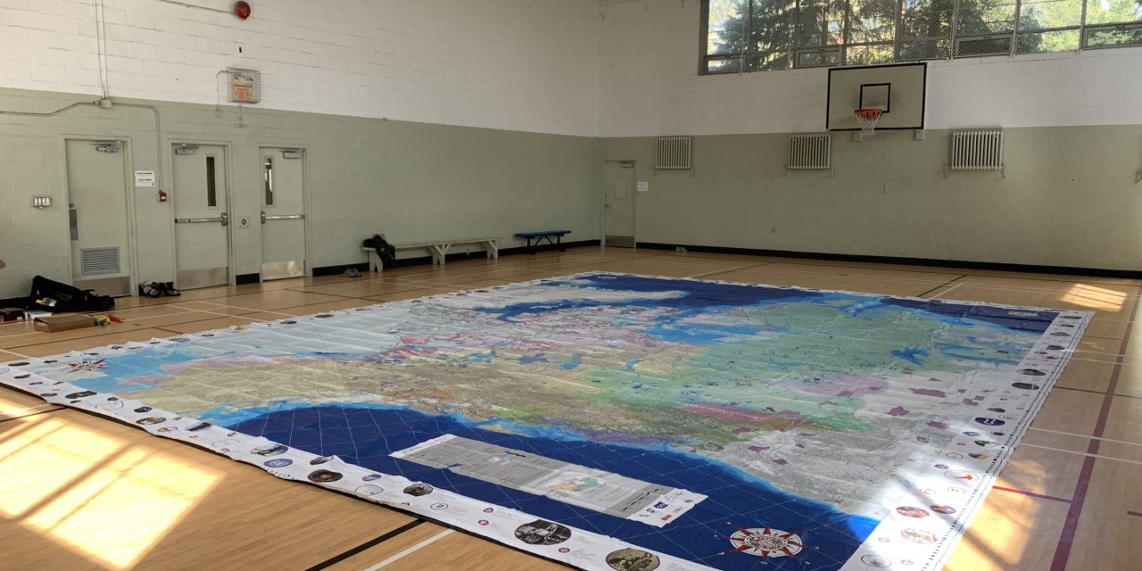
Did you know that the McConnell Foundation recently gifted LEARN an Indigenous Peoples Atlas of Canada (IPAC) giant floor map?
The IPAC Atlas is a way for Indigenous organizations, schools and communities to come together and engage in experiential learning and meaningful discussion on a multitude of topics. It comes with a binder of activities that are specifically designed for elementary and secondary students. The Atlas is also a powerful learning tool for adults and could be used for professional learning in Quebec schools to nurture professional Competency 15: Value and promote Indigenous knowledge, worldviews, culture and history. All of the IPAC activities and supporting documents are available in English and French. Some of the resources also encourage users to learn words from the many Indigenous languages spoken in Canada!
Wondering where to start?
The IPAC teacher’s guide contains learning activities and ways to take action on these topics:
- Climate Change
- Connection to The Land/Demographics
- Indigenous Governance
- Housing
- Human Rights
- Indigenous Languages
- Movement of People
- Notable People
- Original Place Names
- Residential Schools
- Seasonal Cycles and Migration
- Symbols
- Using the Timeline
- Trade Routes and Traplines
- Treaties, Land Disputes, Agreements and Rights
We have now unfolded the atlas twice with students and teachers.
Below are thoughts and reflections from members of the LEARN team.
Sylwia Bielec
I believe learning to be profoundly somatic. It doesn’t happen in the brain, on its own, a little hermetically sealed thought incubator. Deep in the trenches, learning happens through sight and sound and touch and movement. Connected to each other, we learn together when we engage our full selves, limbs and palms and fingers and toes.
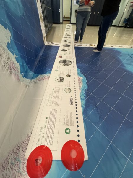
A timeline frames the atlas as well as an additional residential school timeline.
The Indigenous People’s Atlas of Canada (IPAC) map is big. Bigger than you think. To see it open, to walk on it with bare feet, to see others bent over, poring over unfamiliar yet somehow familiar place names is to experience a profound sense of connectedness and realization. This is Canada, Turtle Island. Unfolded bit by bit, a complicated and still unresolved relationship comes to life beneath our feet as we walk tentatively and take in the story told by the rivers, lakes and sheer vastness of the land.
As an immigrant, I am drawn to stories of displacement, of loss and of traveling long distances to see loved ones. The IPAC map throws into sharp relief the size of reserve lands (small) and the distances (vast) between reserve lands of people who share a common language and ancestry. I sank to my knees onto what is now known as Quebec and touched the places scarred by residential schools around James Bay: Ste-Anne’s, Bishop Horden Hall, Ste-Thérèse de l’Enfant Jésus, the federal hostels. Some of the students from Nunavik Sivunitsavut joined me as we looked together for the residential school markers – a school topped with a Christian cross. It was a small thing, and also a very profound thing, to be there with our bodies on the map, tracing with our fingers the paths taken from homes to schools. To walk on and touch the IPAC map is to begin to understand a broken relationship. It is part of our journey towards reconciliation.
Craig Bullett
My personal reaction to the IPAC was to make connections to pedagogy and geography. I saw the physical space of the continent with all the water features and land divisions on it. I could imagine walking with students across the map as a hands-on way to understand scale and help situate our city, province and country in the world. The ‘aha!’ moment for me was the conversations which emerged while walking on the map with students and staff from Nunavik Sivunitsavut.
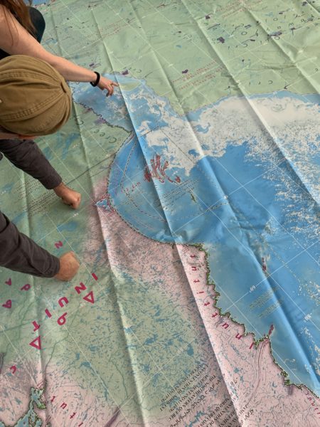
There are many different symbols and labels on the atlas to explore.
Their reaction to the map exposed history and culture which I did not initially see. The student insight also exposed many questions and ethical issues. I am so grateful for this learning (and unlearning) opportunity. The experience was much more profound and emotional than I could possibly have imagined.
Two stories in particular awakened my curiosity to research further as I attempt to piece together the narrative to share here. It also confirmed for me that deeper Truth and Reconciliation will emerge from continued conversations.
The first dialogue involved an activity using the Notable People cards to make connections with regions on the map. Students were asked to read a card to the group and then place the card in the related location on the map. I overheard 2 students discussing the information contained on their card and it was absolutely fascinating. The story ran much deeper than the words on a card.
One student was skeptical that Nunavut filmmaker Zacharias Kunuk was also listed as a sculptor. This fact reminded a second student of an event which actually confirmed the information. The following is a paraphrased version of what the second student clarified.
A community elder had been missing for a month in the wilderness and people were losing hope. After other search efforts were abandoned, a regional pilot with Air Inuit eventually found the missing man which led to him being brought home safely. As a gesture of appreciation, the pilot was presented with a traditional sculpture made by the son of the missing man. And of course, the missing man’s son was none other than Zachharias Kunuk, the Notable Person who appeared on the card. The first student had a big, “oh ya” moment as she recalled the event.
I was eager to dig back into those cards and find out more about this story. You can read more here.
The second conversation involved a sunken ship found in 2016 near King William Island in Nunavut. The ship had been lost since an 1845 expedition to find the Northwest Passage. You can read more on its discovery here. It was interesting to learn that the location where the Erebus sank was called Umiaktalik by the local Inuit for some time before the 2016 discovery, and that Umiaktalik means the “boat place” in Inuktitut. Afterwards, we also learned that a local Inuk, Louie Kamookak, worked with the Coast Guard to help locate the sunken ship.
The entire experience was an important reminder that the activities which go with the IPAC are only the beginning. More content and stories will surface as a product of exploring the IPAC together. It is so important to capture the missing stories so we can build the resources which will accompany the IPAC in its travels. I believe this will continue to bring further clarity, understanding, and appreciation of Indigenous culture.
Stacy Allen
Even after having looked at photos and videos about the IPAC Atlas, I was still awestruck when we unfolded it for the first time. It is very powerful to take off your shoes, step onto the map, and view the vastness of the territory from an aerial perspective.
One of the first things that struck me when looking at the atlas was how large the territory of ‘Canada’ is compared to the small purple squares representing reserve land and reserve parcel land. It is emotional to see the sheer multitude of symbols and labels that denote treaties land agreements; they entice you to learn more about the communities and past and present negotiations.
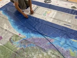
People can use rope and the scale to estimate distance and area.
The atlas comes with pylons and rope to mark different areas, symbols and events. At this year’s CCI conference, educators placed pylons on all of the residential and day school symbols in Quebec. This could be one activity that schools could do throughout the year, especially when honouring the National Day for Truth and Reconciliation. So whether you teach math, social sciences or even the arts, there are many ways to include this multi-dimensional resource in your class.
While the atlas comes with many resources, we want to include more resources developed by the 11 Indigenous Nations of Quebec. LEARN is working with students at Nunavik Sivunitsavut to create resources on Nunavik. We are also working on resources that integrate digital competency, including this cartograf map and student guides to create interactive timelines.
Booking the Atlas
The LEARN IPAC Atlas is on loan to Quebec’s 10 English school boards, as well as the QAIS, AJDS, FNEC, Cree SB and Kativik SB. It is also available to McGill University, Concordia University & Bishop’s University. LEARN will work with interested schools before the map arrives to help plan targeted learning activities depending on where your school is located in terms of geography and integrating the Calls to Action. We recommend booking the Atlas for a one-week period. The borrower is responsible for all shipping fees. Schools that are interested in borrowing the atlas can book here.
The IPAC map and its accompanying resources were printed by Canadian Geographic and created in partnership with numerous Indigenous and ally organizations and educators throughout Canada, including (but not limited to), the Assembly of First Nations, Inuit Tapiriit Kanatami, Métis National Council.
Resources
Special thanks to Charlene Bearhead, the Director of Reconciliation at Canadian Geographic, who approached LEARN. LEARN had collaborated with Project of Heart which is an ongoing project across Canada, with resources for educators. We supported teachers and students to find ways to engage in the Quebec English schools for the Project of Heart which looks at the “true history of the Indian Residential School system in Canada.” This stop-motion video is one example of this project.